Former Antilles, congratulations!
October 10 2010 (10-10-10) is a historic date, it is the day the “De Nederlandse antillen” seize to exist. Today St. Maarten and Curaçao become autonomous countries with in the “Kingdom of the Netherlands”. Bonaire, St. Eustatius and Saba become municipalities of the Netherlands. A special kind of municipalities, not all rights and assets common to municipalities in the Netherlands will be available to these beautiful islands.
The Dutch OpenStreetMap community focuses on the small piece of land geographically located between the North sea, Germany and Belgium, but a lot of dutch people are somehow connected socially or otherwise to the (former) antilles. I have been an enthusiastic mapper for OpenStreetMap for years mainly busy mapping Aruba. I am curious if others are putting similar effort in mapping the other islands. Therefor I am constantly looking for help and geodata in that particular, extraordinary beautiful region of the world.
Aruba
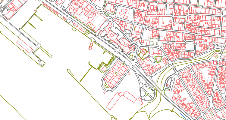
Two years ago, I received geodata for Aruba last updated in 2005. The data originates from CAD-drawings and was cut-up in what looks like paper-sheet format for large print/plot. Besides that, the data consists of line-work only.
The data is outdated. Beside that, lines are “messy” with a lot of over- and undershoots, disconnected or missing chunks. Automated imports are strongly discouraged. The geodata does not contain any names or labels, making it almost impossible to create addresses and streetnames unless you have been to Aruba or are living on Aruba. What I did, is make the Aruba dataset available as a WMS server, hoping to atract people from the island to join me in mapping it. The WMS server runs on the dogomaps domain. A simple demo can be viewed here.
Using the WMS service
For Merkaartor, you can point the WMS adapter to:
http://www.dogomaps.net/geoserver/wms?
When you use this link correct, Merkaartor will detect the available layers. The best layer to pick would be the one labeled “Aruba” because it joins all the other layers in to one and thus limits the traffic to the server.
In JOSM you can set up the service URL:
The WMS url for retrieving the GetCapabilities is:
http://www.dogomaps.net/geoserver/ows?service=wms&version=1.1.1&request=GetCapabilities
I hope this initiative will encourage others to help me enhance OpenStreetMap for Aruba and hopefully we can set up a good example for the other former antilles to follow.
I want to congratulate all the people on the islands with there new “freedom”, hope they celebrate and party and wish them a prosperous future!